
Haz una donación
Mapa topográfico Mount Snow
Haga clic en el mapa para ver la altitud.
Haz una donación
Acerca de este mapa
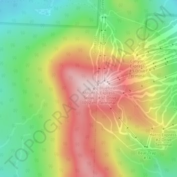
Nombre: Mapa topográfico Mount Snow, altitud, relieve.
Lugar: Mount Snow, Windham County, Vermont, 05356, United States (42.95920 -72.92381 42.95930 -72.92371)
Altitud media: 864 m
Altitud mínima: 667 m
Altitud máxima: 1,091 m
Haz una donación
Otros mapas topográficos
Haga clic en un mapa para ver su topografía, su altitud y su relieve.
South Londonderry
United States > Vermont > Windham County > Londonderry > South Londonderry Village Historic District
Altitud media: 365 m
Rockingham
United States > Vermont > Windham County
The highest point in town is Berry Hill at 478 m/1568 ft elevation, near the northwestern corner of the town. The lowest point is on the Connecticut River at the southern boundary of town, at 73 m/240 ft elevation.
Altitud media: 227 m
Brattleboro
United States > Vermont > Windham County
The town's densely populated center is located near Vermont's lowest elevation point in the Connecticut river valley. Because of the surrounding steep hills there is very little flat land, and many of its buildings and houses are situated on steep hillsides, necessarily closely bunched together. This…
Altitud media: 184 m
Haz una donación
Jamaica
United States > Vermont > Windham County
The charter goes on to say “that the same be and is hereby Incorporated into a Township by the name of Jamaica”—its name from the Natick word for beaver and not the Caribbean island. The grant encompassed forty-two square miles, at an altitude ranging from 688 feet (210 m) above sea level along the West…
Altitud media: 419 m
Brattleboro
United States > Vermont > Windham County
The town's densely populated center is located near Vermont's lowest elevation point in the Connecticut river valley. Because of the surrounding steep hills there is very little flat land, and many of its buildings and houses are situated on steep hillsides, necessarily closely bunched together. This…
Altitud media: 184 m
Haz una donación
Wilmington
United States > Vermont > Windham County
Wilmington experiences a humid continental climate (Koppen Dfb) with warm, humid summers and cold (sometimes severely cold) winters. While snowfall can vary greatly from year to year in nearby towns like Bennington and Brattleboro, Wilmington's snowfall is consistently heavy each year because of its elevation…
Altitud media: 578 m
Haz una donación
Haz una donación
Wilmington
United States > Vermont > Windham County
Wilmington experiences a humid continental climate (Koppen Dfb) with warm, humid summers and cold (sometimes severely cold) winters. While snowfall can vary greatly from year to year in nearby towns like Bennington and Brattleboro, Wilmington's snowfall is consistently heavy each year because of its elevation…
Altitud media: 578 m
Haz una donación
Jamaica
United States > Vermont > Windham County
The charter goes on to say “that the same be and is hereby Incorporated into a Township by the name of Jamaica”—its name from the Natick word for beaver and not the Caribbean island. The grant encompassed forty-two square miles, at an altitude ranging from 688 feet (210 m) above sea level along the West…
Altitud media: 419 m
Haz una donación
Haz una donación
Brattleboro
United States > Vermont > Windham County
The town's densely populated center is located near Vermont's lowest elevation point in the Connecticut river valley. Because of the surrounding steep hills there is very little flat land, and many of its buildings and houses are situated on steep hillsides, necessarily closely bunched together. This…
Altitud media: 184 m
Haz una donación