
Gracias por apoyar a este sitio ❤️
Haz una donación
Haz una donación
Mapa topográfico Carcross
Haga clic en el mapa para ver la altitud.
Gracias por apoyar a este sitio ❤️
Haz una donación
Haz una donación
Acerca de este mapa
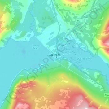
Nombre: Mapa topográfico Carcross, altitud, relieve.
Lugar: Carcross, Yukon, Y0B 1B0, Canada (60.12922 -134.74958 60.20922 -134.66958)
Altitud media: 782 m
Altitud mínima: 642 m
Altitud máxima: 1,305 m
Gracias por apoyar a este sitio ❤️
Haz una donación
Haz una donación
Otros mapas topográficos
Haga clic en un mapa para ver su topografía, su altitud y su relieve.
Kluane National Park and Reserve
The Reserve includes the highest mountain in Canada, Mount Logan (5,959 metres or 19,551 feet) of the Saint Elias Mountains. Mountains and glaciers dominate the park's landscape, covering 83% of its area. The rest of the land in the park is forest and tundra—east of the largest mountains and glaciers—where…
Altitud media: 1,536 m
Gracias por apoyar a este sitio ❤️
Haz una donación
Haz una donación