
Gracias por apoyar a este sitio ❤️
Haz una donación
Haz una donación
Mapa topográfico Rønde
Haga clic en el mapa para ver la altitud.
Gracias por apoyar a este sitio ❤️
Haz una donación
Haz una donación
Rønde
Rønde is a hill town, with a 95-meter difference in elevation between the lowest and highest part. This kind of grade difference is unusual for Denmark, where the overall highest point in the country is 172 meters above sea level.
Gracias por apoyar a este sitio ❤️
Haz una donación
Haz una donación
Acerca de este mapa
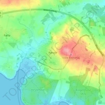
Nombre: Mapa topográfico Rønde, altitud, relieve.
Altitud media: 31 m
Altitud mínima: -2 m
Altitud máxima: 96 m
Gracias por apoyar a este sitio ❤️
Haz una donación
Haz una donación
Otros mapas topográficos
Haga clic en un mapa para ver su topografía, su altitud y su relieve.