
Gracias por apoyar a este sitio ❤️
Haz una donación
Haz una donación
Mapa topográfico Churchill Butte
Haga clic en el mapa para ver la altitud.
Gracias por apoyar a este sitio ❤️
Haz una donación
Haz una donación
Acerca de este mapa
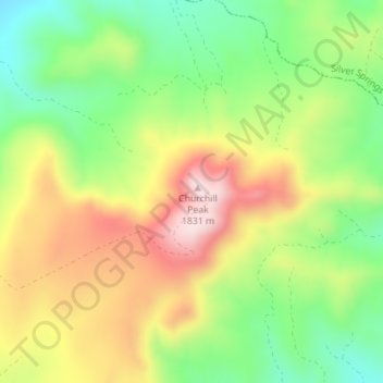
Nombre: Mapa topográfico Churchill Butte, altitud, relieve.
Lugar: Churchill Butte, Lyon County, Nevada, 89429, United States (39.33931 -119.29605 39.33941 -119.29595)
Altitud media: 1,645 m
Altitud mínima: 1,484 m
Altitud máxima: 1,836 m
Gracias por apoyar a este sitio ❤️
Haz una donación
Haz una donación
Otros mapas topográficos
Haga clic en un mapa para ver su topografía, su altitud y su relieve.
Yerington
United States > Nevada > Lyon County
During the summer, temperatures are generally hot to very hot in the afternoon, but the high altitude and low humidity means temperature drop to a comfortable level at night. On average, 8.0 afternoons each summer will exceed 100 °F or 37.8 °C and 73.2 afternoons reach 90 °F (32.2 °C). It is rare, though,…
Altitud media: 1,358 m