
Gracias por apoyar a este sitio ❤️
Haz una donación
Haz una donación
Mapa topográfico Ledbetter
Haga clic en el mapa para ver la altitud.
Gracias por apoyar a este sitio ❤️
Haz una donación
Haz una donación
Acerca de este mapa
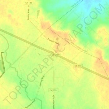
Nombre: Mapa topográfico Ledbetter, altitud, relieve.
Lugar: Ledbetter, Fayette County, Texas, 78946, United States (30.13091 -96.81172 30.17091 -96.77172)
Altitud media: 128 m
Altitud mínima: 108 m
Altitud máxima: 139 m
Gracias por apoyar a este sitio ❤️
Haz una donación
Haz una donación
Otros mapas topográficos
Haga clic en un mapa para ver su topografía, su altitud y su relieve.
La Grange
United States > Texas > Fayette County
The center of La Grange has an elevation of 266 feet (81 m) above sea level.
Altitud media: 91 m
Gracias por apoyar a este sitio ❤️
Haz una donación
Haz una donación
La Grange
United States > Texas > Fayette County
The center of La Grange has an elevation of 266 feet (81 m) above sea level.
Altitud media: 91 m