
Haz una donación
Mapa topográfico Kiruna
Haga clic en el mapa para ver la altitud.
Haz una donación
Kiruna
Kiruna is located in the north of Sweden, 145 kilometres (90 mi) north of the Arctic circle. The city centre is built on the Haukavaara hill at an altitude of 530 m, high above the Torne river to the north and the Kalix river to the south. Other parts of the town are Lombolo and Tuolluvaara. Near Kiruna are the mountains Kiirunavaara and Luossavaara. Kiirunavaara is an iron ore mine that is the town's primary economic resource. Luossavaara is a former mine and now used as a skiing slope.
Haz una donación
Acerca de este mapa
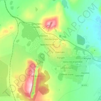
Nombre: Mapa topográfico Kiruna, altitud, relieve.
Lugar: Kiruna, Kiruna kommun, Norrbotten County, 981 32, Sweden (67.81507 20.18555 67.89507 20.26555)
Altitud media: 511 m
Altitud mínima: 413 m
Altitud máxima: 726 m
Haz una donación
Otros mapas topográficos
Haga clic en un mapa para ver su topografía, su altitud y su relieve.
Haz una donación
Abisko National Park
Permafrost is common in the national park, though permafrost at lower elevations is disappearing because of global warming and increased snowfall.
Altitud media: 740 m
Haz una donación
Haz una donación
Haz una donación
Torneträsk
Permafrost is common in the land around the lake. This low elevation permafrost is disappearing because of global warming and increased snowfall.
Altitud media: 768 m
Haz una donación
Haz una donación
Haz una donación
Haz una donación